21st GEOGRAPHY
#geographyteacher #geography #map #maps
#geografia #earth #EarthEngine
#NationalGeographic
Geography
|
Geography is a field of science devoted to the study of the lands, features, inhabitants, and phenomena of the Earth and planets. The first person to use the word γεωγραφία was Eratosthenes. Wikipedia
Human Population Through Time
t took 200,000 years for our human population to reach 1 billion—and only 200 years to reach 7 billion. But growth has begun slowing, as women have fewer babies on average. When will our global population peak? And how can we minimize our impact on Earth’s resources, even as we approach 11 billion? #humans #population #humanevolution #overpopulation Download the video in HD: http://media.amnh.org/sciencebulletin...
|
History of the Earth in 5 1/2 minutesAnimated timeline from the graphic novel 'Science: a Discovery in Comics' by Margreet de Heer. More info:http://margreetdeheer.com/eng/science...
|
Geography Resources:
|
Mapping:
TAKE A SEAT ROAD TRIP GEOGRAPHY
Whether you are exploring your neighborhood, your city, the United States, or the world, you need to understand how cities, countries, and continents make up the world. Geography is the study of places around the world and how they connect with each other. When you learn about geography, you learn about maps, physical places and landmarks, cultures, and how all of it ties together. Traveling by car across the United States or taking a seat on a plane headed around the world can be great ways to learn about geography, but you can get started learning about this subject just by looking at maps.
Content include resources on:
-As identified by Ms. Vogel and her students at lakecountytutor.com
Crash Course Geography
Crash Course Geography Preview
Welcome to Crash Course Geography hosted by Alizé Carrère! This course with be split into two parts. In the first half, we will focus on physical geography or the processes and phenomena of the physical world both above and below the Earth's surface. We'll ask questions like, "why is the seafloor so young when the Earth is so old?" or try to identify why winds and ocean currents are so important to life on Earth. Then we'll turn our focus to human geography and explore the ways people occupy the Earth's surface. Like how we've moved, settled, and used the land, resources and space. But ther'e not always a clear line dividing the physical and human, because really, geography is telling the story of the Earth. We'll hope you'll join us on this journey starting November 30, 2020!
|
Nation Comparison
Geography Trivia
20 Trivia Questions (Geography) No. 120 Trivia Questions (Geography) No. 1
For Geography Trivia 2: https://www.youtube.com/watch?v=bf_Qw... For Geography Trivia 3: https://www.youtube.com/watch?v=KvGdO... Twitter & Geography
Mapping Games
World Geography and Oceans: Online Games and Quizzes
Written By: Frank Bongiorno -As identified by Ms. Cisneros, Stella, Nessa, and Kason
Interviewed by NATIONAL GEOGRAPHIC?!Lots has happened in the past few weeks and lots more in the coming months! www.facebook.com/GeographyNowFanpage www.instagram.com/Paulbarbato www.twitter.com/GeographyNow
The World: Timeline of National Flags: 1019 - 2020
The history of the world with flags, from parts of history during the medieval and modern periods, from 1019 - 2020.
|


National Geographic Society
The National Geographic Society uses the power of science, exploration, education and storytelling to illuminate and protect the wonder of our world.Since 1888, the National Geographic Society has driven impact by identifying and investing in an international community of Explorers: leading scientists, educators, storytellers, conservationists, technologists, and many other changemakers who help us define some of the critical challenges of our time, drive new knowledge, advance new solutions, and inspire positive transformative change.
Since awarding our first grant in 1890, we have provided more than 14,000 grants for work across all seven continents. This includes the most comprehensive scientific expedition to Mount Everest, working to better understand human-carnivore conflict in Gorongosa, telling stories that help explain the world and all that’s in it, and groundbreaking work that has transformed our understanding of the great apes and what it means to be human. We also engage audiences around the globe through signature experiences, stories, and content, including the National Geographic Museum at our headquarters in Washington, D.C. A look back at National Geographic's first 130 yearsWe've been around for more than 130 years of discoveries, innovation, and impact. For our 130th birthday in January 2018, we took a look back at our history. natgeo.org/timeline
National Geographic Resources:SUBJECTS
|
YouTube Channel:
Inspiring people to care about the planet! National Geographic is the world's premium destination for science, exploration, and adventure. Through their world-class scientists, photographers, journalists, and filmmakers, Nat Geo gets you closer to the stories that matter and past the edge of what's possible.
National Geographic Education
At National Geographic, we teach kids about the world and how it works, empowering them to succeed and to make it a better place.
GeoBee: GeographyWhat is a border? What is a peninsula? A look into why geography is important to understand as students around the country prepare for the 2013 National Geographic Bee.
Flat Earth vs. Round Earth | ExplorerThe Ancient Greeks concluded Earth was a sphere, which has been validated by scientists ever since. Despite this, there is a movement growing claiming the Earth is flat.
2010 National Geographic Bee - Why Geography Matters by Google EarthA look behind the scenes into why Geography matters, as students around the country prepare for the 2010 National Geographic Bee. Download Google Earth at earth.google.com
|

National Geographic:
Traditional Geography
Earth 101 | National GeographicEarth is the only planet known to maintain life. Find out the origins of our home planet and some of the key ingredients that help make this blue speck in space a unique global ecosystem. ➡ Subscribe: http://bit.ly/NatGeoSubscribe
Hurricanes 101Find out how hurricanes can be so destructive.
Volcanoes 101About 1,500 active volcanoes can be found around the world. Learn about the major types of volcanoes, the geological process behind eruptions, and where the most destructive volcanic eruption ever witnessed occurred.
|
Earthquakes 101When the trembling stops, the disaster is only the beginning.
Tsunami 101Find out how a tsunami is born and how it destroys.
Tornadoes 101Find out how tornadoes can be so destructive.
|
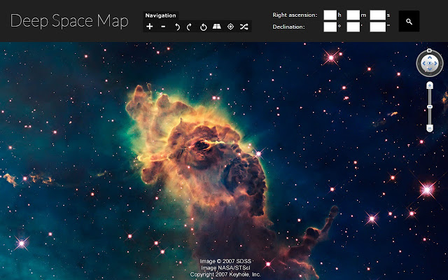
Geography through Google
Google Earth Tutorial: Intro to Creation ToolsLearn how to start a project and add place marks, lines, photos and more. Try it out now: https://g.co/earth
Google Earth Training for Educators:From the Google Tutorials & Tips site:
Basic Tutorials and Tips
If you haven't already checked out our suggestions for how to bring the world to your students through Google Earth, check out Google Earth Features For My Class. We know that you’re already working hard, so we’ve organized some of Google Earth’s most popular features into themes as suggestions as to which features to tackle and learn first. If you're just getting started you should ensure that you first know how to: Once you've mastered these basics, you may wish to tackle Google Earth through one of the following themed areas of interest:
Learn Google Earth: Historical ImageryTravel back in time with Historical Imagery in Google Earth. Download the latest version at earth.google.com
Learn Google Earth: Recording a TourBaseball Stadium Tour in Google EarthTake a virtual road trip to all your favorite baseball stadiums just in time for the new season. Explore them in 3D using Google Earth.
Jacques Cousteau's Ocean World in Google EarthIn honor of Jacques Cousteau's 100th birthday, take a highlight tour of historic video clips from Cousteau's famous ocean travels with the Cousteau Society in Google Earth.
3D Buildings And TerrainWith Google Earth, you can see 3D buildings from the ground up in many places around the world. Tilt the screen to see the buildings in 3D. Similarly, the terrain is also mapped in 3D, meaning you can see mountains, valleys and canyons in vivid detail.
Whale Protected Areas Google Earth TourMeet sperm whales, humpback whales and blue whales in the special places where they live. This Google Earth Tour, narrated by Dan Laffoley, Marine Vice Chair of the International Union for Conservation of Nature (IUCN)'s World Commission on Protected Areas, follows the migrations of whales above and below the surface and visits some of the key marine protected areas and sanctuaries for whales around the world. Join the blue whale in the US national marine sanctuaries off California and journey to the proposed Costa Rica Dome Marine Protected Area in the Eastern Tropical Pacific, one of the key areas being proposed as part of the "Homes for Whales" project of the Whale and Dolphin Conservation Society. Follow the humpbacks on migration, from their breeding grounds to the feeding areas in the North Atlantic around the Stellwagen Bank National Marine Sanctuary, and visit one of the most recent protected areas, the Agoa Sanctuary in the French Caribbean. This animated Google Earth Tour was first presented as part of a keynote lecture by Dan Laffoley (IUCN) at the opening of the 2nd International Conference on Marine Mammal Protected Areas (ICMMPA) on 7 November 2011 in the Atrium, Fort-de-France, Martinique. It was prepared with the help of Jenifer Austin Foulkes (Google), Charlotte Vick (Sylvia Earle Alliance/Mission Blue) and Erich Hoyt (Whale and Dolphin Conservation Society/IUCN).
EDU in 90: Google Earth in the ClassroomIt’s now easier than ever to bring the world inside your classroom. Join Tim and A.T. on this episode of EDU in 90 to understand how you can bring Google Earth into your classroom.. Google Earth is a web based 3D virtual globe that presents the world’s geographic information ranging from natural sciences to social sciences, history, art, and engineering in a geospatial context. Learn how to use Google Earth to engage your students and explore our educator resources at www.google.com/earth/education.
EDU in 90: Innovate with Google EarthGoogle Earth is a tool that’s flexible, engaging, and easy to integrate into the classroom. Join Tim and Morgan as they look at classroom uses from educators like you - everything from Layers and discussion prompts to writing activities and Earth Bingo.
Introducing creation tools in Google EarthSee how a classroom, a conservationist and a family use the new creation tools in Google Earth to share stories about the places that matter to them.
Google Earth Engine combines a multi-petabyte catalog of satellite imagery and geospatial datasets with planetary-scale analysis capabilities and makes it available for scientists, researchers, and developers to detect changes, map trends, and quantify differences on the Earth's surface.
Meet Earth Engine |
What can you do with geography?We all know that geography is important; but what can you do with it? As students across the country prepare for the 2012 National Geographic Bee, we've explored how geography is used in the real world, from disaster response to military intelligence and even polar exploration. We wish all competitors good luck in this year's competition!
Google Maps - LearnHistory
Science
Space Science
Math
Geography
Google Street View
Google Street View enables you and your students to explore many of the world's treasures up close without leaving the classroom. The Google Cultural Institute brings together millions of artifacts from multiple partners, with the stories that bring them to life, in a virtual museum.
Tutorials
New to Google Maps and Google Earth? We have a host of short tutorials and videos to help you get started. Start with the introductory set and then before you know it, you will be ready for the more advanced content. Introductory Sterling High School - Creating a Google Map in GeographyStudents in World Geography and Human Geography use Google Maps to create their own map. Students pin locations and type information about that country and it is embedded in the map. This is a daily warm-up for students.
Google Maps design: Exploring color
Google Maps Staff Designer Dana Steffe explains how a minimalist approach to color and a study of natural environments unlocked the team's ability to show people a more detailed representation of the world. Learn more: https://design.google/library/explori...
Google Sky, Mars, Moon & OceansGoogle Sky, Mars, and MoonExplore beyond your world in your browser with Google Sky, Google Mars, and Google Moon.
Google Sky & Sky MapAllows you to view celestial objects, including stars, constellations, galaxies, planets and the Earth's moon.
Sky Map - Astronomy App for Android
Kevin Serafini, software engineer on the Sky Map team, demonstrates the updated Sky Map app for Android.
Google MarsSpacecraft, Canyons, Ridges. Stories, Dunes, Craters. Search. Link this view · View Mars with Google Earth
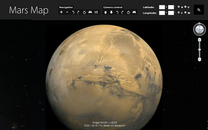
Mars in Google Earth
Explore Mars in Google Earth 5.0. Be the first human to view images from NASA, take a narrated tour by Mars experts, view 3D rover models and search for famous Martian landmarks. Download at http://earth.google.com/mars
Google MoonA photographic map of the equatorial region with pan and zoom capability, showing locations of the Apollo landings.
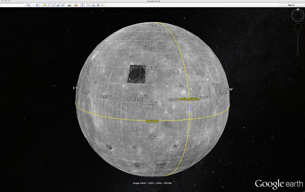
Moon in Google Earth
Land on the Moon in Google Earth. With Moon in Google Earth, you can take tours narrated by Apollo astronauts, view 3D models of landed spacecraft, zoom into 360-degree photos, and watch rare TV footage of the Apollo missions. Download Google Earth 5.0 to start exploring the Moon. http://earth.google.com/moon/
Google OceansExplore the ocean with Google MapsGoogle Maps strives to provide people around the globe with the most comprehensive, accurate and usable map of the world - including the underwater world. This ocean collection includes six of the world's most incredible underwater spots, including coral reefs (and their inhabitants) in Australia, the Philippines and Hawaii. This imagery is available to millions of people through the Street View feature of Google Maps and in our Street View Gallery at: maps.google.com/ocean. These images were collected by our partner, The Catlin Seaview Survey: http://www.catlinseaviewsurvey.com
The World's Ocean
|


Geocaching & Geotagging
What is Geocaching?
Geocaching is the real-world adventure that's happening right now, all around you. Watch this video to learn more about what geocaching is, how it works and how you can become a part of it. After the video, head over to Geocaching.com to create your free account and to get started. Happy geocaching! http://www.geocaching.com/
Viewing Geocaches with Google Earth. The Geocaching Google Earth Viewer allows you to see up to 500 geocaches within a particular map view. A "map view" is ...
Geocaching;
Geocaching at Ohio Historical Sites:
Welcome to Geocaching! Do you want to test your skills in a whole new way at the Ohio History Connection sites? Why not try geocaching? Geocaching is a combination of a treasure hunt and a hike that requires the use of a global positioning system (GPS) receiver. While some people define it as a sport and others a hobby, it is an activity that can be enjoyed individually or with groups of friends or family. Let's show you what the Ohio History Connection has to offer those who want to connect with Ohio's past while participating in this sensational new form of adventure. www.ohiohistory.org/museums-and-historic-sites/geocaching |
Geotagging, or GeoTagging, is the process of adding geographical identification metadata to various media such as a geotagged photograph or video, websites, SMS messages, QR Codes or RSS feeds and is a form of geospatial metadata. Wikipedia
Learn Google Earth: Geotagging PhotosWith Google Earth, you can see 3D buildings from the ground up in many places around the world. Tilt the screen to see the buildings in 3D. Similarly, the terrain is also mapped in 3D, meaning you can see mountains, valleys and canyons in vivid detail.
This is an example of using Google MyTracks on an Android phone with GPicSync (desktop app) to create a Google Map with geotagged photos. You can click ...
GPS photo tagging, also known as geotagging, is the process of embedding a digital photo with latitude, longitude and even altitude data. ... Other users can search or browse by tags to find the most relevant content. GPS photo tagging can cut down on the amount of work it takes to tag images on the Internet.
When you take a photo with your GPS on, it stores its physical location where the photo was taken. Geotagging assigns coordinates to photos.
Geotagging:
|
Cultural Geography: Food
EAT: The Story Of Food
EAT: THE STORY OF FOOD
Food. It’s driven nearly everything we’ve ever done as a species, and yet it’s one of the most overlooked aspects of human history. In the beginning, our hunger drove us to hunt. Then, it led us to plant and settle, resulting in civilization. We conquered the land, and we went out into the ocean and then the larger world. We filled our bellies, but it still wasn’t enough. Because as humans became more sophisticated, so did our needs—we searched for flavor and convenience, adapting science and technology to match our cravings. Whether for meat or sugar, junk food or beer, humanity’s appetite has altered the planet, shaped our history and even altered our future. This six-part series is the epic story behind food and how it made us “us.” EAT: The Story Of Food -How Food Connects UsNo matter the nationality, the one common language humanity has in common is food.
|

Resources for Teaching about Food and Food Issues
education.nationalgeographic.com theplate.nationalgeographic.com Basic Bites Explore our reference library for fundamental food terms and concepts: A Forest Garden With 500 Edible Plants Could Lead to a Sustainable Future | Short Film ShowcaseInstead of neat rows of monoculture, forest gardens combine fruit and nut trees, shrubs, herbs, vines and perennial vegetables together in one seemingly wild setting. This type of agroforestry mimics natural ecosystems and uses the space available in a sustainable way. UK-based Martin Crawford is one of the pioneers of forest gardening. Starting out with a flat field in 1994, his land has been transformed into a woodland and serves as an educational resource for others interested in forest gardening. This short film by Thomas Regnault focuses on Crawford's forest garden, which is abundant, diverse, edible, and might be one answer to the future of food systems.
|
USA: Regional Food Cultures
Pop vs Soda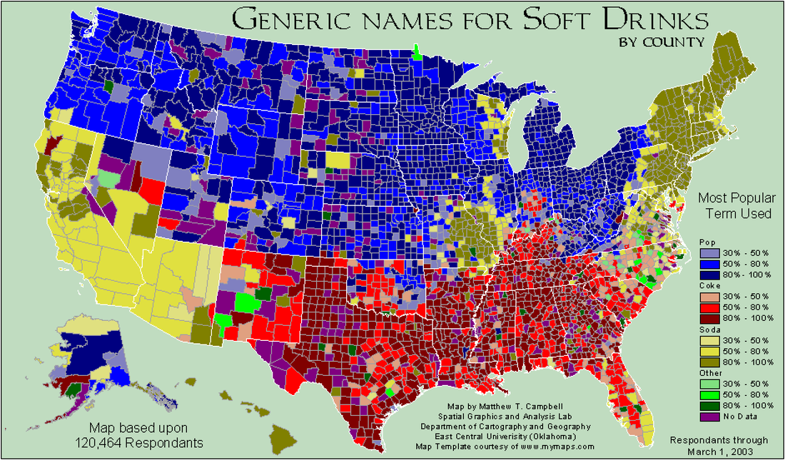
ABOUT
The Pop vs Soda Page is a web-based project to plot the regional variations in the use of the terms "Pop" and "Soda" to describe carbonated soft drinks. You can help by filling out the survey! Mapping How Americans Talk - Soda vs. Pop vs. CokeWhat's your general term for a sweetened carbonated beverage? What word or words do you use to address a group of two or more people? What do you call it when the rain falls while the sun is shining?
|
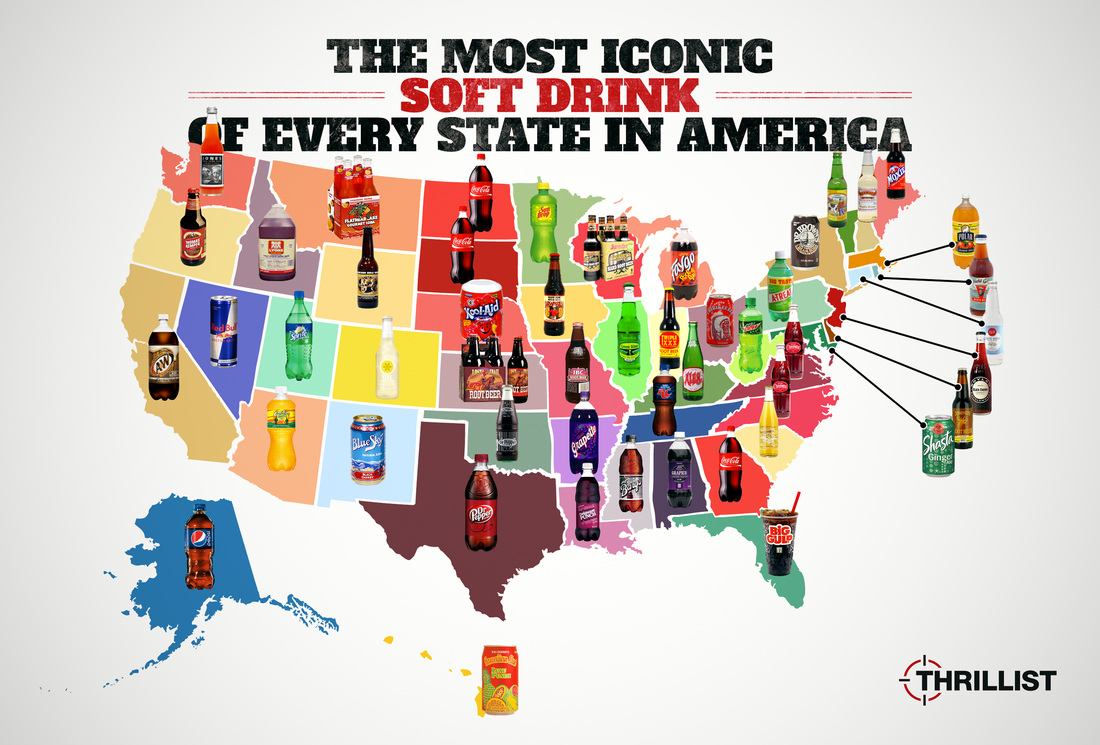
The Iconic Soft Drink of Every State In America
Regional Fast Food Restaurants We Wish Were Everywhere
One of the highlights of any U.S. road trip is hitting up fast-food joints along the way. These grab-and-go restaurants are built around their core communities, founded by people who are passionate about their product, and staffed by locals who make it all happen. Regional fast food restaurants make traveling in the U.S. totally delicious. But chances are, those flavors can only be found in certain parts of the country. Here are a few of the most uniquely regional fast food restaurants we wish we could dig into everywhere…
|
World: Food Cultures
We Are What We Eat
|
After traveling to five different countries (Greenland, Bolivia, Malaysia, Pakistan, Crete) in search of the origins of the human diet, Matthieu Paley comes to the last stop in his journey, Tanzania.
After traveling to five different countries (Greenland, Bolivia, Malaysia, Pakistan, Crete) in search of the origins of the human diet, Matthieu ...
We Are What We Eat: Greenland - Nat Geo LiveThe Inuit of Greenland have survived for generations eating almost nothing but meat. Photographer Matthieu Paley captures the bloody job of securing a meal in this remote territory.
We Are What We Eat: Tanzania - Nat Geo LivePhotographer Matthieu Paley joins the Hadza of Tanzania--the world’s last full-time hunter-gatherers.
We Are What We Eat: Pakistan - Nat Geo LivePhotographer Matthieu Paley travels to the Hunza Valley in northern Pakistan where evening meals are a celebration not to be missed, with an assortment of chai and capatis sprinkled with apricot oil.
|
We Are What We Eat: Bolivia - Nat Geo LivePhotographer Matthieu Paley journeys to the Bolivian Amazon where getting a meal is a family affair for the Tsimane people, as children often scavenge for food and gut hunted animals.
We Are What We Eat: Afghanistan - Nat Geo LiveJoin photographer Matthieu Paley in the mountains of Afghanistan where no crops grow, the journey to get flour takes days, and goat eyes are on the menu.
We Are What We Eat: Crete - Nat Geo LiveThe people living on the Greek island of Crete love their wine and eat a rich variety of foods drawn from their groves, farms, and the sea. Photographer Matthieu Paley captures the joyful people that have lived on the Mediterranean diet long before it became a fad.
We Are What We Eat: Borneo - Nat Geo LiveMatthieu Paley photographs the Bajau of Malaysia, who fish and dive for almost everything they eat. Some live in houses on stilts over the water; others live in boats where they sleep, fish, and cook
|
Atlas Pro
|
Geography, geology, biology, and ecology. That's what we'll be talking about here at Atlas Pro. Well that and maybe some history, chemistry, and whatever else is really necessary to explain something. Point is, we're trying to learn more about the Earth, it's systems, and maybe more. Subscribe if that colors you intrigued!
The Geography of Spices and HerbsFun fact, I got the idea for this video while working as a cook in a Taco Bar.
The Geography of Vegetables
The stunning conclusion to everyone's favorite geography series.
|
The Geography of FruitHere's where our most popular fruits originated from
The Geography of Livestock
Here's where the animals we eat come from.
|
Street Food
Street food consists of ready-to-eat foods or drinks sold by a hawker, or vendor, in a street or other public place, such as at a market or fair. It is often sold from a portable food booth, food cart, or food truck and meant for immediate consumption. Wikipedia
|
35 Iconic Street Foods Every World Traveler Must Try
35 Iconic Street Foods Every World Traveler Must Try · Aloo chaat (South Asia) · Anticucho (Peru) · Arepa (Colombia and Venezuela) · Asinan ( ... Street Food World
Follow us as we explore our way through the world, feasting on interesting sights and amazing food!
YouTube Channel: Street Food World
|
Best Street Food Around the World: 50 Favorite Street Food ...
Use the street food dish you seek as the final destination. Many of the world's most fascinating markets and remarkable street food stalls are found ... Street Food Around The World
From eye to hand to mouth, Ishai Golan is taking you into the world’s kitchens of the streets, markets and alleyways hiding the best street food. Local chefs and clued-in residents come along for the ride, helping Ishai lift the lid on their city’s best-kept cooking secrets.
YouTube Channel: Street Food Around The World
|